
 Price: $499.00
W/External Antenna
Price: $479.99
W/Internal Antenna
What's in the Box:
|
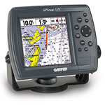
Own the lake with the GPSMAP 172C and its counterpart, the GPSMAP 178C Sounder. With a bright, sunlight-readable color display and worldwide marine basemap, the 172C is ready to chart your next marine adventure.
Chart Your Course
The GPSMAP 172C features a built-in worldwide marine basemap and accepts MapSource® BlueChart® offshore marine cartography, featuring detailed depth contours, inter-tidal zones, wrecks, navaids, and many other points of interest. For small-water anglers, the 172C is compatible with MapSource Recreational Lakes with Fishing Hot Spots, featuring fishing areas, boat ramps, marinas, and hazards for hundreds of popular U.S. and Canadian lakes. You can also use compatible preprogrammed data cards, which insert easily into the slot on the front of the plotter.
GPSMAP 172C: Chart your course with this versatile plotter
|
||||||||||||||||||||||||
 Price: $599.99
What's in the Box:
|
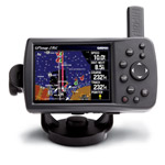
The GPSMAP 276C is a versatile color chartplotter and automobile navigator, perfect for land or water. Along with its counterpart, the GPSMAP 376C, this portable navigator features a sunlight-readable 256-color TFT display and a built-in autorouting basemap that can route you on major interstates and highways.
Head for the Water
On water, the GPSMAP 276C is a dependable color chartplotter with built-in basemap enhanced by Garmin's marine cartography. For extra-precise navigation, the 276C has a Course Deviation Indicator (CDI) a feature normally found on aircraft, but equally practical for the marine environment. The CDI quickly indicates whether your boat has veered off-course and helps you get back on track quickly. The 276C also supports external NMEA sources for water depth, water temperature, and water speed through two serial interfaces.
Navigate on Land
On land, the GPSMAP 276Cs autoroute basemap can route you on interstates and major highways. For even more detail, get the optional automotive kit (sold separately), which includes City Navigator® detailed maps, a data card and an automotive mount. With this kit, just load the detailed street maps on your 276C and pop it into the automotive mount for voice-prompted turn-by-turn directions to over six million addresses and points of interest, including restaurants, hotels, gas stations, marinas and other attractions.
Add More Marine Maps
The 276C is compatible with BlueChart® maps, which add extra detail when you're out on the seas. It also accepts optional MapSource® data cards, so you can add other types of map data easily. For convenience and easy map transfer, you can connect the 276C to your computer with the included USB cable.
GPSMAP 276C: The perfect navigator for water or land
|
||||||||||||||||||||||||
 Price: $899.99
What's in the Box:
|
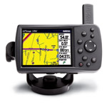
The GPSMAP 376C is a versatile color chartplotter and automobile navigator, perfect for land or water. Along with its counterpart, the GPSMAP 276C, this portable navigator features a sunlight-readable 256-color TFT display and a built-in autorouting basemap that can route you on major interstates and highways.
Head for the Water
On water, the GPSMAP 376C is a dependable color chartplotter with built-in basemap enhanced by Garmin's marine cartography. For extra-precise navigation, the 376C has a Course Deviation Indicator (CDI) a feature normally found on aircraft, but equally practical for the marine environment. The CDI quickly indicates whether your boat has veered off-course and helps you get back on track quickly. The 376C also supports external NMEA sources for water depth, water temperature, and water speed through two serial interfaces.
Navigate on Land
On land, the GPSMAP 376Cs autoroute basemap can route you on interstates and major highways. For even more detail, get the optional automotive kit (sold separately), which includes City Navigator® detailed maps, a data card and an automotive mount. With this kit, just load the detailed street maps on your 376C and pop it into the automotive mount for voice-prompted turn-by-turn directions to over six million addresses and points of interest, including restaurants, hotels, gas stations, marinas and other attractions.
Get XM Satellite Weather
See real-time weather on the 376C's high-resolution TFT with the included GXM 30 XM antenna and a subscription to XM Satellite Weather and Radio services. View vital weather data, including NEXRAD radar, storm cells, wind speeds, surface temperatures, forecasts and more than a dozen other weather attributes, so you can enjoy the water without worrying about the weather. You can also subscribe to XM Satellite Radio to receive over 100 channels of commercial-free music, sports, news and talk radio.
Add More Marine Maps
The 376C is compatible with BlueChart maps, which add extra detail when you're out on the seas. It also accepts optional MapSource data cards, so you can add other types of map data easily. For convenience and easy map transfer, you can connect the 376C to your computer with the included USB cable.
GPSMAP 376C: The perfect navigator for water or land.
|
||||||||||||||||||||||||
 Price: $999.99
What's in the Box:
|
Go straight from the box to your boat to your vehicle with the portable GPSMAP 378. Along with its counterpart, the GPSMAP 478, this combination color chartplotter and street navigator comes preloaded with detailed marine maps and detailed street maps, so you can find your way anywhere.
Head Straight for the Water
Ready for action right out of the box, the GPSMAP 378 comes preloaded with detailed U.S. Inland Lakes data, which boasts 10-meter resolution for more than 3200 lakes, many with depth contours. In addition, these built-in freshwater maps provide shoreline detail, river and creek channels, islands, boat ramps, campgrounds and more for tens of thousands of lakes across the continental U.S. giving you the freedom to boat and fish anywhere in the states. The maps also show streams and rivers, tide stations and predictions, a wrecks and obstructions database and U.S. Coast Guard aids to navigation.
Go from Water to Land
When you're ready to drive home, take your 378 out of its marine mount and pop it into the automotive mount in your vehicle. Then press one button, and your 378 is ready to navigate you on the roads, with turn by turn directions and voice prompts that take you straight to your destination. The 378 is preloaded with detailed City Navigator maps for all of North America and contains over 6 million points of interest, including hotels, restaurants, gas stations, marinas, attractions and more.
Add Optional Weather, Audio and Sonar
See real-time weather on the 378's high-resolution TFT with the purchase of a GXM 30 XM antenna and a subscription to XM Satellite Weather and Radio services. View vital weather data, including NEXRAD radar, storm cells, wind speeds, surface temperatures, forecasts and more than a dozen other weather attributes, so you can enjoy the water without worrying about the weather. You can also subscribe to XM Satellite Radio to receive over 100 channels of commercial-free music, sports, news and talk radio.
For serious fishing, pair the 378 with the GSD 21 remote sounder, which offers 4,000 watts of power peak-to-peak (500 watts RMS) with a dual-frequency transducer (purchased separately).
Add More Marine Maps
The 378 accepts optional MapSource data cards, so you can add new maps without connecting to your computer. Optional BlueChart g2 data cards let you view real, detailed aerial photos of harbors, marinas and other important marine landmarks and places, right on your chartplotter.
GPSMAP 378: Loaded and ready for action, right out of the box
|
||||||||||||||||||||||||
 Price: $999.99
What's in the Box:
|
Go straight from the box to your boat to your vehicle with the portable GPSMAP 478. Along with its counterpart, the GPSMAP 378, this combination color chartplotter and street navigator comes preloaded with detailed marine maps and detailed street maps, so you can find your way anywhere.
Head Straight for the Water
Ready for action right out of the box, the GPSMAP 478 comes preloaded with US marine detailed maps for the entire US coast, including Alaska and Hawaii. These maps are based on BlueChart g2 technology, so they layer smoothly and are integrated for easy panning, scrolling and zooming.
Go from Water to Land
When you're ready to drive home, take your 478 out of its marine mount and pop it into the automotive mount in your vehicle. Then press one button, and your 478 is ready to navigate you on the roads, with turn by turn directions and voice prompts that take you straight to your destination. The 478 is preloaded with detailed City Navigator maps for all of North America and contains over 6 million points of interest, including hotels, restaurants, gas stations, marinas, attractions and more.
Add Optional Weather, Audio and Sonar
See real-time weather on the 478's high-resolution TFT with the purchase of a GXM 30 XM antenna and a subscription to XM Satellite Weather and Radio services. View vital weather data, including NEXRAD radar, storm cells, wind speeds, surface temperatures, forecasts and more than a dozen other weather attributes, so you can enjoy the water without worrying about the weather. You can also subscribe to XM Satellite Radio to receive over 100 channels of commercial-free music, sports, news and talk radio.
For serious fishing, pair the 478 with the GSD 21 remote sounder, which offers 4,000 watts of power peak-to-peak (500 watts RMS) with a dual-frequency transducer (purchased separately).
Add More Marine Maps
The 478 accepts optional MapSource data cards, so you can add new maps without connecting to your computer. BlueChart g2 data cards let you view real, detailed aerial photos of harbors, marinas and other important marine landmarks and places, right on your chartplotter.
GPSMAP 478: Loaded and ready for action, right out of the box
|
||||||||||||||||||||||||
 Price: $499.99
Chartplotter
Price: $599.99
Chartplotter/Sounder
What's in the Box:
*Note: 420s package includes dual frequency transducer
|
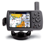
The GPSMAP 420 is a sleek, space-saving chartplotter that features an ultra-bright 4 QVGA display; built-in, satellite-enhanced worldwide basemap and simplified user operation. The 420 also has an SD card slot so you can add additional features with the optional BlueChart® g2 Vision card.
View Satellite-enhanced Maps
The 420s basemap contains worldwide satellite images in place of more traditional maps, and its SD card slot makes it easy to add additional maps without connecting to a computer. With fewer keys and a simple, intuitive interface, the 420 makes navigating your way through the water easy.
Add Sonar
Where applicable, the sounder version, GPSMAP 420s, comes with a powerful dual frequency transducer that clearly paints depth contours, fish targets and structure whether youre fishing in freshwater or off the coast. The 420 and 420s are also CANet compatible, so you can share sounder data with another chartplotter on your boat.
Add Extras with BlueChart g2 Vision
With the optional BlueChart g2 Vision SD card, you can add a whole new dimension of exceptional features to your chartplotter.
|
||||||||||||||||||||||||
 Price: $549.99
Chartplotter
Price: $599.99
Chartplotter/Sounder
What's in the Box:
*Note: 430s package includes dual beam transducer
|
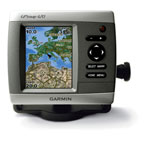
This sleek, space-saving chartplotter is your companion for freshwater fishing and boating. The GPSMAP 430 features preloaded detailed maps for U.S. inland lakes as well as an ultra-bright 4 QVGA display; built-in, satellite-enhanced worldwide basemap and simplified user operation.
Navigate Any Lake
The 430 comes preloaded with detailed maps for U.S. inland lakes, including 5300 lakes with shoreline, depth contours, navaids and more. Over 300 of these lakes are enhanced with extra Inland Lakes Vision features (see below). For areas outside the U.S., the 430 has a worldwide basemap with satellite images in place of more traditional maps, and its SD card slot makes it easy to add additional maps without connecting to a computer. With fewer keys and a simple, intuitive interface, the 430 makes navigating your way through the water easy.
The 430 boasts advanced Inland Lakes Vision features for 300 of the most popular lakes.
Add Sonar and Weather
The sounder version, GPSMAP 430s, comes with a dual beam transducer that clearly paints depth contours, fish targets and structure. Its also CANet compatible, so you can share sounder data with another chartplotter on your boat. The weather-enabled versions, GPSMAP 430x and 430sx, display XM satellite weather data, including NEXRAD radar, with the GXM 31 antenna.
Add Extras with BlueChart® g2 Vision
With the optional BlueChart g2 Vision SD card, you can add a whole new dimension of exceptional features to your chartplotter for offshore use, including advanced 3D perspective, Auto guidance, high-resolution satellite images, detailed fishing charts and more.
|
||||||||||||||||||||||||
 Price: $599.99
Chartplotter
Price: $699.99
Chartplotter/Sounder
What's in the Box:
*Note: 440s package includes dual frequency transducer
|
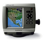
Offshore fishermen and boaters will gravitate toward this sleek, space-saving chartplotter. The GPSMAP 440 features preloaded detailed maps for the U.S. coast as well as an ultra-bright 4 QVGA display; built-in, satellite-enhanced worldwide basemap and simplified user operation.
Chart the High Seas
The 440 has preloaded detailed maps that cover all U.S. coastal areas, including Alaska and Hawaii. For areas outside the U.S., the 440 has a worldwide basemap with satellite images in place of more traditional maps, and its SD card slot makes it easy to add additional maps without connecting to a computer. With fewer keys and a simple, intuitive interface, the 440 makes navigating your way through the water easy.
Add Sonar and Weather
Where applicable, the sounder version, GPSMAP 440s, comes with a powerful dual frequency transducer that clearly paints depth contours, fish targets and structure. Its also CANet compatible, so you can share sounder data with another chartplotter on your boat. The weather-enabled versions, GPSMAP 440x and 440sx, display XM satellite weather data, including NEXRAD radar, with the GXM 31 antenna.
Add Extras with BlueChart® g2 Vision
With the optional BlueChart g2 Vision SD card, you can add a whole new dimension of exceptional features to your chartplotter.
|
||||||||||||||||||||||||
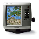 Price: $699.99
Chartplotter
Price: $799.99
Chartplotter/Sounder
What's in the Box:
*Note: Where applicable, 520s package includes dual frequency transducer
|
This slim-line chartplotter flush-mounts easily in your boat and boasts an ultra-bright 5 QVGA display. The GPSMAP 520 also sports a built-in, satellite-enhanced worldwide basemap and simple, straightforward buttons and menus. You can add the optional BlueChart® g2 Vision SD card for even more enhanced features.
Navigate with Ease
With just a few buttons and a simple, intuitive interface, the GPSMAP 520 makes navigating virtually effortless. And instead of a traditional basemap, the 520 has a basemap of worldwide satellite images. It also has an SD card slot so you can add additional detailed maps without connecting to a computer.
Add Sonar
Where applicable, the sounder version, GPSMAP 520s, comes with a powerful dual frequency transducer that clearly paints depth contours, fish targets and structure whether youre fishing in freshwater or off the coast. The 520 and 520s are also CANet compatible, so you can share sounder data with another chartplotter on your boat.
Add Extras with BlueChart g2 Vision
With the optional BlueChart g2 Vision SD card, you can add a whole new dimension of exceptional features to your chartplotter.
|
||||||||||||||||||||||||
 Price: $899.99
Chartplotter
Price: $1099.99
Chartplotter/Sounder
What's in the Box:
*Note: Where applicable, 525s package includes dual frequency transducer
|
This slim chartplotter boasts the brightest, sharpest, most colorful graphics youve ever seen on a 5-inch screen. The GPSMAP 525 has a 5 VGA display; built-in, worldwide satellite-enhanced basemap; and simple, straightforward buttons and menus. You can add the optional BlueChart® g2 Vision SD card for even more enhanced features.
Navigate with Ease
The 525s worldwide basemap includes realistic satellite imagery that shows up clearly on its crisp, ultra-bright screen. The SD card slot makes it easy to add additional maps without connecting to a computer. And with a simple, intuitive interface and high-speed processor, the 525 makes navigating easy.
Add Sonar
Where applicable, the sounder version, GPSMAP 525s, comes with a powerful dual frequency transducer that clearly paints depth contours, fish targets and structure whether youre fishing in freshwater or off the coast. Its also CANet compatible, so you can share sounder data with another chartplotter on your boat.
Add Extras with BlueChart g2 Vision
With the optional BlueChart g2 Vision SD card, you can add a whole new dimension of exceptional features to your chartplotter.
|
||||||||||||||||||||||||
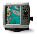
 Price: $699.99
Chartplotter
Price: $799.99
Chartplotter/Sounder
What's in the Box:
*Note: 530s package includes dual beam transducer
|
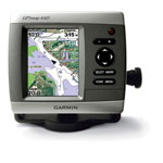
The slim-line, freshwater GPSMAP 530 flush-mounts easily in your boat and sports preloaded, detailed maps for U.S. inland lakes. The 530 also features a 5 QVGA display and simple, straightforward buttons and menus. You can add the optional BlueChart g2 Vision SD card for even more enhanced features.
Navigate Any Lake
The 530 comes preloaded with detailed maps for U.S. inland lakes, including 5300 lakes with shoreline, depth contours, navaids, and more. Over 300 of these lakes are enhanced with extra Inland Lakes Vision features (see below). For areas outside the U.S., the 530 has a worldwide basemap with satellite images in place of more traditional maps. The SD card slot makes it easy to add additional maps without connecting to a computer. And with just a few buttons and a simple, intuitive interface, the 530 makes navigating your way through the water easy.
The 530 boasts advanced Inland Lakes Vision features for 300 of the most popular lakes.
Add Sonar and Weather
The sounder version, GPSMAP 530s, comes with a powerful dual frequency or dual beam transducer that clearly paints depth contours, fish targets and structure. Its also CANet compatible, so you can share sounder data with another chartplotter on your boat. For continuously-updated weather information, you can add the optional GXM 31 antenna to receive XM satellite weather, including NEXRAD radar, and hundreds of XM radio stations right on your chartplotter.
Add Extras with BlueChart® g2 Vision
With the optional BlueChart g2 Vision SD card, you can add a whole new dimension of exceptional features to your chartplotter for offshore use, including advanced 3D perspective, Auto guidance, high-resolution satellite images, detailed fishing charts and more. Learn more about BlueChart g2 Vision.
|
||||||||||||||||||||||||
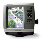
 Price: $899.99
Chartplotter
Price: $1099.99
Chartplotter/Sounder
What's in the Box:
*Note: 535s package includes dual beam transducer
|
This freshwater chartplotter boasts the brightest, sharpest, most colorful graphics youve ever seen on a 5-inch screen. The GPSMAP 535 has a 5 VGA display; preloaded, detailed maps of U.S. inland lakes; and simple, straightforward buttons and menus. You can add the optional BlueChart g2 Vision SD card for even more enhanced features.
Navigate the Lake
The 535 comes preloaded with detailed maps for U.S. inland lakes, including 5300 lakes with shoreline, depth contours, navaids, and more. Over 300 of these lakes are enhanced with extra Inland Lakes Vision features (see below). For areas outside the U.S., the 535 has a worldwide basemap with satellite images in place of more traditional maps. The SD card slot makes it easy to add additional maps without connecting to a computer. And with a simple, intuitive interface and high-speed processor, the 535 makes navigating easy.
The 535 boasts advanced Inland Lakes Vision features for 300 of the most popular lakes.
Add Sonar and Weather
The sounder version, GPSMAP 535s, comes with a powerful digital sounder (up to 1 kW) and dual beam transducer that clearly paints depth contours, fish targets and structure. Its also CANet compatible, so you can share sounder data with another chartplotter on your boat. For continuously-updated weather information, you can add the optional GXM 31 antenna to receive XM satellite weather, including NEXRAD radar, and hundreds of XM radio stations right on your chartplotter.
Add Extras with BlueChart® g2 Vision
With the optional BlueChart g2 Vision SD card, you can add a whole new dimension of exceptional features to your chartplotter for offshore use, including advanced 3D perspective, Auto guidance, high-resolution satellite images, detailed fishing charts and more. Learn more about BlueChart g2 Vision.
|
||||||||||||||||||||||||
 Price: $799.99
Chartplotter
Price: $899.99
Chartplotter/Sounder
What's in the Box:
*Note: Where applicable, 540s package includes dual frequency transducer
|
This offshore mariners chartplotter flush-mounts easily in your boat and sports preloaded BlueChart g2 maps for the coast of the U.S. and Bahamas. The GPSMAP 540 also features a 5 QVGA display and simple, straightforward buttons and menus. You can add the optional BlueChart g2 Vision SD card for even more enhanced features.
Navigate the High Seas
The 540 has preloaded detailed maps covering all U.S. coastal areas and the Bahamas. For other areas, the 540 has a worldwide basemap with satellite images in place of more traditional maps. The SD card slot makes it easy to add additional maps without connecting to a computer. And with just a few buttons and a simple, intuitive interface, the 540 makes navigating your way through the water easy.
Add Sonar and Weather
Where applicable, the sounder version, GPSMAP 540s, comes with a powerful dual frequency transducer that clearly paints depth contours, fish targets and structure whether youre fishing in freshwater or off the coast. Its also CANet compatible, so you can share sounder data with another chartplotter on your boat. For continuously-updated weather information, you can add the optional GXM 31 antenna to receive XM satellite weather, including NEXRAD radar, and hundreds of XM radio stations right on your chartplotter.
Add Extras with BlueChart® g2 Vision
With the optional BlueChart g2 Vision SD card, you can add a whole new dimension of exceptional features to your chartplotter.
|
||||||||||||||||||||||||